
Last modified: 2019-10-21 by ian macdonald
Keywords: bahia | cotegipe |
Links: FOTW homepage |
search |
disclaimer and copyright |
write us |
mirrors
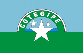 image located by Valentin Poposki, 1
September 2019
image located by Valentin Poposki, 1
September 2019
Cotegipe was established in 1820, as Campo Largo. In 1925, the municipality
was renamed to Barăo de Cotegipe, subsequently shortened to Cotegipe.
The
town's namesake, Joăo Maurício Wanderley (1815-1889), Baron of Cotegipe, was
President of the Province of Bahia (1853-1866), Senator (1846-1889), President
of the Council of Ministers (1885-18888), and President of the Bank of Brazil
(1888-1889).
The flag was designed in 1990 by Jarildes de Jesus Matos de
Souza (b. 1972), then student at Colégio Estadual Jutahy Magalhăes, winner of a
contest open to the town's educational institutes.
The flag is
horizontally divided into two equal parts. The upper, blue part represents the
sky, while the lower, green part, represents the big forests and mango groves
that surround the town. They were mostly located on the banks of the river that
divides Cotegipe, supplying at the time abundant water used to shower and for
laundry, and now lifeless because of deforestation.
The semi-circle
represents Rio Grande that waters the municipality and is a significant source
of income for its neighbors, who live from fishing and agriculture, mainly in
the districts of Jupaguá and Taguá.
The bigger, central star represents the
seat of the municipality. The middle-sized star represents Jupaguá, and the
smaller star represents Taguá.
http://cotegipe-page.blogspot.com/2011/09/historia-da-bandeira-de-cotegipe.html,
Cotegipe-P@ge blog
Photos:
https://jornalgazetadooeste.com.br/noticias/suplente-de-vereador-antonio-feitoza-toma-posse-na-camara-de-cotegipe/
Video:
https://www.youtube.com/watch?v=44al3ouukF8
Ivan Sache, 6
September 2019